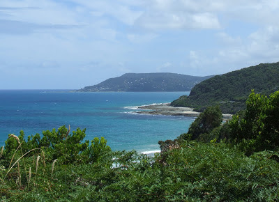
Sunday, February 10, 2013

Warrnambool and Tower Hill

As we were now well into the peak holiday season with tourist operators scaring Freedom Travellers such as ourselves into believing that there was absolutely no accommodation available anywhere we prudently accepted the first campsite we came across at Hopkins River. This suited us very well as, being a few kilometres away from Warrnambool, it was in a wide open space and, being bordered by the river with farms all around, also allowed us to forget that we were in a big park with hundreds of other holiday makers.
Hopkins River, Victoria
Except for fishing, for which you need a boat, there's nothing to do in the immediate vicinity at Hopkins River so we headed to Warrnambool just five kilometres away. Situated on the mouth of the Hopkins River Warrnambool is a pleasant city of about 34,000 people with trees and parks providing eye appeal. The seaside was rather breezy and holiday makers were instead enjoying the fun parks and cafes, leaving the beach for all but a few brave souls.


War Memorial, Warrnambool
This Memorial sits high on the hill so cannot be missed. I was pleased to see that the Warrnambool women who lost their lives received a mention.

I'd only heard of howitzers so I was interested to see these from the 1914 - 1918 war. The killing machines certainly have become very much more accurate and efficient in the past hundred years. I was interested to learn that the modern howitzer was invented in the late 1600s by Sweden, a country that is not nowadays quickly associated with war.
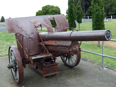
Howitzer 1914 - 1918
The port at Warrnambool had its hey day during the Victorian gold rush period in the 1850s. Today we saw leisure craft and a couple of tourist cruise boats.
Warrnambool
As it was just a little windy to walk on the beach we decided to head for Port Fairy however a sign indicating a Reserve caught my attention and I turned down a narrow, twisty one way road, much to the consternation of my spouse who likes to know exactly where we are going!
Tower Hill Road
His protestations ceased abruptly when he spotted this emu on the road and reached for a camera. From that moment on I had made a good choice!
Emu
We had previously seen wild emus only twice - once from the train near Rockhampton and once north of Port Douglas - hence the excitement.[ Once we were settled at a picnic table the enthusiasm wore off as several of them tried to snatch the food off our plates.]
The road continued, passing small lakes until a sign informed us that we had arrived at Tower Hill Reserve. This seemed to be just the kind of place we liked - a peaceful place with trees and water and wild life all around. Noticing that we were sheltered from the wind, we decided to have lunch and then visit the Information Centre to get an idea of what this place was all about.
Koala in a gum tree
Our visit here lasted three hours or so and koala slept the whole time, occasionally opening an eye and shifting a little to offer some excitement to the multi national visitors' clicking cameras.
Wagon Bay Walk, Tower Hill
Our visit to the Information centre informed us that Tower Hill is the site of a volcano that erupted about 32,000 years ago forming a shallow crater which later filled with water. The conical shaped hills [ see the emu on the road photo] are the result of subsequent eruptions. 

There are several different walks visitors can enjoy and we selected the easiest of these, the Wagon Bay Walk. Our leisurely stroll took us around one of the small lakes, small birds flitting away as we approached and things rustling in the undergrowth - echidnas, I thought, as the rustlings were too noisy for snakes. A one point a fallen tree crossed the narrow track so some contortionism was required to get under it!
Wagon Bay Lake, Tower Hill
Near Tower Hill, Victoria
A very pleasant afternoon in a special place, Tower Hill features on our list of trip highlights.

Tuesday, February 5, 2013

The Twelve Apostles, Great Ocean Road

 The Great Ocean Road hugs the coastline from Torquay to Apollo Bay where it climbs the hills to transverse Cape Otway. There it briefly rejoins the coast at Glenaire before again climbing to Lavers Hill and again returning to the coast. It was a very enjoyable and varied route passing through National Parks and forests as well as providing brilliantly coloured sea vistas. We stopped briefly at Lorne and found it to be a laid back holiday town with the seafront lined with cafes, restaurants and holiday apartments. There we obtained very useful maps and other items from the Information Centre in the centre of the town. Our lunch stop was at Otway Junction where we found another delightful cafe with a small historical museum onsite.
Gibsons Steps
Travelling east to west, Gibsons Steps lookout was our first sighting of the limestone cliffs that are a feature of the landscape since crossing the Otway. The name apparently came from a settler Hugh Gibson, who maintained the steps - 86 of them - which were originally carved out of the cliffs. Nowadays they are a sturdy staircase going down to a beach so dangerous that signs warning against swimming or standing under the cliffs are prominently displayed. 
Limestone sea stack
There are two sea stacks known as Gog and Magog! I have no idea who got the naming rights! They are not considered to be part of the Twelve Apostles which are a very short distance down the road.

The limestone cliffs were especially pretty with a range of green hues and flowers. 


The Twelve Apostles, Great Ocean Road
These world famous limestone sea stacks - some call them the 13th Wonder of the World - shone brilliantly in the bright sun. They were originally called the Sow and Piglets with the Sow located near Loch Ard Gorge and the smaller ones here being her piglets. They were renamed as the Twelve Apostles purely for marketing and tourism purposes despite the fact that there were, at that time, only nine of them. In 2005 one succumbed to the pounding of the sea and blast of the winds and fell into the sea leaving the current eight to fascinate the many tourists from all over the world who travel this famous road. Of course erosion never ceases and eventually new stacks will be formed, probably just where we stand today, breathing in their beauty and gaining a healthy respect for the power of the elements.
The Twelve Apostles


The wind and sea erosion has created wonderful patterns and textures and I am well pleased that my ancient Fuji zoom was able to capture the detail for my continued enjoyment.
London Bridge, Great Ocean Road
A short distance down the road we stopped at London Bridge. This bridge used to have two natural arches until 1990 when the one closest one collapsed leaving two tourists stranded.


London Bridge prior to 1990
 [ I'd like to credit the photographer but unfortunately no source was given.]
The Arch
Few people stop at the Bay of Islands and I enjoyed having the place to myself as I listened to the faint crashing of waves below, my eyes feasting on the contrasting, vibrant colours of the limestone, water and vegetation.
Bay of Islands, Great Ocean Road
How disappointed I was that I didn't have the stitch mode of my G12 to capture this intriguing and beautiful place.
Bay of Islands
I was told that about two centimetres each year is eroded from the base of the sea stacks in this area. This one looks thin at both bottom and top!


Bay of Islands
In the absence of stitch, the picture above is the best I could do to record my memories of this awesome place.

The sights along our world famous road had more than met my expectations! Happily we continued on our way to Hopkins River, near Warrnambool which was to be as far as we were going along this memorable coast.

Monday, February 4, 2013

Aireys Inlet on the Great Ocean Road,Victoria

On our last evening in Lakes Entrance we enjoyed a leisurely time on Ninety Mile Beach appreciating the muted but lovely sunset and calm conditions. During the night, however, a strong wind arrived and by 4am next morning we decided to give up trying to secure guy ropes and poles and take down our camp. Contending with the force of the wind and also trying not to disturb our neighbours was not easy. When they later emerged from their tents it was to tell us that this was their very first tent experience and that they had been too terrified to come out while it was dark!  By 7 am we were waiting for my sister to appear to say our farewells before leaving, our destination for the day being Aireys Inlet on the other side of Port Phillip Bay.

We decided to take the Princes Highway, a decision later regretted as it was a rather dull road with few interesting places to stop to take a break from the wind that frequently sideswiped the van. During our trip we came to the conclusion that New South Wales road signage is far better than that in Victoria with information there of upcoming turnoffs and exits appearing well before their locations. In vain we looked for the exit we needed and in the end found ourselves heading for Port Phillip instead of Sorrento where we planned to take the ferry cross Port Phillip Bay to Queenscliffe. Yet another cup of service station coffee, accompanied by almost accurate directions,  eventually got us to Sorrento.

The ferry runs on the hour and takes just forty minutes and we enjoyed the break in the cafe, out of the wind. Dolphins often play alongside the ferry however they gave that a miss today. Probably it was too windy for them!


Sorrento
Queenscliffe on the other side of the bay is a popular holiday spot and, as I drove through the town I could see its charm in the well maintained buildings, cafes and restaurants and beach.

Queenscliffe
Anticipation rising, we headed for the famous Great Ocean Road and our first stop along it, Aireys Inlet.

Just past Angelsea we had our first glimpse across the sea of the Lighthouse at Aireys Inlet.
Near Angelsea
Our three days at Aireys Inlet were very pleasant despite the ferocious wind that kept blowing for the first two days. The nights and mornings especially cold requiring three layers of clothing which, living in Queensland we were not comfortable with. Now that Sam's back had mostly recovered, mine decided to let me know it wanted some attention so our exploring was mostly by vehicle.
Split Point Lighthouse, Aireys Inlet.
This lighthouse, standing high on the cliff top, reminded me of a tall white chimney. Now known by locals by its nickname "White Queen" it was, until 1913, named Eagles Nest Point Lighthouse. In 1890, the year building started, ten ships were wrecked along this treacherous part of the coastline. The lighthouse was commissioned the next year and was manned until 1919 when it was automated.
Three clothing layers and not that warm!
Split Point, Aireys Inlet
There is another lighthouse at Cape Otway, ninety kilometres away by road with this part of the south coast being known as "Shipwreck Coast". The currents and rough seas of Bass Strait, together with frequent mists, often proved deadly for ships carrying passengers and  goods. There are at least 638 known wrecks from an unnamed whaling ship in 1836 to the famous American naval ship the City of Rayville which was sunk by a German laid mine in 1940. Although it was very windy when we were there and the sea did not look wild, I would not like to be out there in stronger winds!
Aireys Inlet
Our last day gave us easier weather conditions so we were able to take a walk along the lovely beach. The water was surprisingly warm to paddle in - few people were actually swimming however families were having fun playing volleyball and beachcombing.
near Fairhaven, Victoria
near Aireys Inlet
The sight of this house had cars lining up along the roadside to take photos. I don't think that I'd like to be up there on a windy day!
Mt Defiance Lookout, Great Ocean Road
In 1917 the plan to build the road now famously known as "The Great Ocean Road" was put forward by civilians who were keen to make it easier to travel between the seaside towns along the way and a Trust was formed to build it. 

I was horrified to learn that soldiers returning from World War 1 where they had survived those atrocities themselves, losing many brothers and mates, were put to work with picks and shovels on this massive task. I thought of my own grandfather who, falsifying his age to go to war, suffered physically and mentally for the remainder of his life after it and was I glad that he was better treated in New Zealand. The point has been made that these returned servicemen were provided with work on their return however to put them to work in this way still seems ungrateful and harsh to me.
Great Ocean Road Arch
This is the actually third arch here with the first one which was constructed in 1937 being replaced when the road was widened in 1973. Ten years later that was burned down in the Ash Wednesday bushfires and the present one constructed.
Commemorating the returned soldier workers who built the road
Memorial plaques, Great Ocean Road
As we continued along towards our next destination, The Twelve Apostles, we stopped at several plaques placed along the road giving information about the history of this famous road.